Friday, August 8, 2008

Schematic


A schematic detailing a concept layout for a housing blueprint. Schematics can map the location of structural elements and their order of placement.

Taken from HERE.

Periodic Table of Elements


The periodic table of elements maps the name and abbreviation of an element to information such as its atomic number and weight.

Taken from HERE.

Electrical Circuit


A flow map of electrical current in a closed circuit.

Taken from HERE.

DNA Diagram


A map detailing the components of a DNA molecule.

Taken from HERE.

Timeline


A chronological map of the history of the Earth's major geological time periods.

Taken from HERE.

Network Map


A flow map detailing the semantic connections of a network server.

Taken from HERE.

Array Map


An array maps data values together in a matrix for easy lookup access by computer systems. This array details human proteins associated with arthritis.

Taken from HERE.

Portolan Chart


A Portolan chart detailing the Earth at latitudes near the Tropic of Capricorn. Portolan charts were early European navigational maps that combined the practical application of accurate navigational elements (such as detailed shoreline contours) and decorative illustration.

Taken from HERE.

Isopach


An isopach describing the boundaries of an oil reservoir. Isopachs use contour lines to describe the thickness of stratified layers of the Earth's surface and subsurface.

Taken from HERE.

Bathymetric


A bathymetric chart of the Hawai'ian island chain. Bathymetric maps detail underwater topographic information such as the contour of the ocean floor and rising sea mounts.

Taken from HERE.

Star Plot


Star Plots are a method of describing multivariate observations that include an arbitrary number of variables. Each observation is represented as a star-shaped figure with a single ray of proportional length describing the value of each variable.

Taken from HERE.

Correlation Matrix


Correlation Matrices describe correlations between a number of values.

Taken from HERE.

Similarity Matrix


A Similarity Matrix is a matrix of value scores representing the similarity between a given two data points. Data is mapped across both the X- and Y- axis allowing a row/column comparison of values. In this example darker red colors depict higher levels of similarity.

Taken from HERE.

Stem and Leaf Plot


Stem and Leaf plots are graphical representations of quantitative data used to help visualize the shape of distributions. Unlike histograms stem and leaf plots maintain data in their logical order and to at least two significant digits. This stem and leaf plot is a fictitious example with no specific data being described.

Taken from HERE.

Box Plot


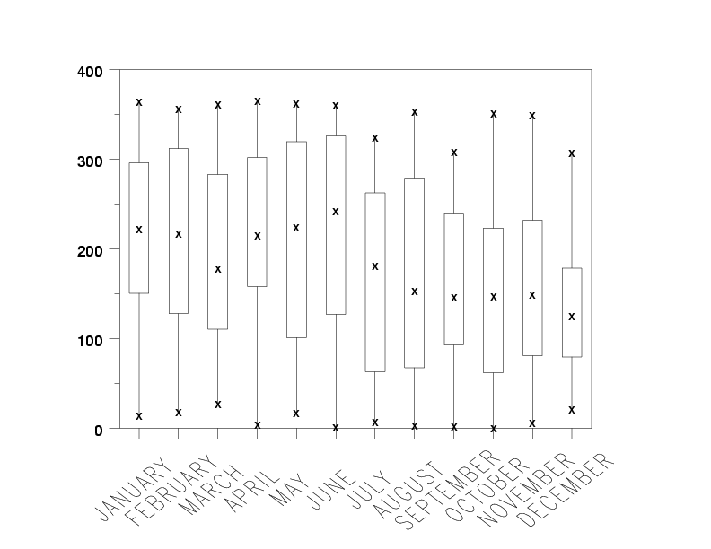
Box plots graphically describe groups of numerical data through their five-point summary (smallest observation, lower quartile, median, upper quartile and largest observation). The spacing between each of the five points describes the size of dispersion between observations and helps to identify outlying data. This map describes some unknown variable observed over a 12-month period.

Taken from HERE.

Histogram


Histograms graphically display frequency data in a bar graph format. As opposed to a typical bar graph, histograms represent information as a function of the total area of the bars rather than a vertical Y-value. This is an important distinction to make when data categories are of non-uniform widths. This example tracks company resources in terms of manpower hours for the fiscal year 2005-2006.

Taken from HERE.

Parallel Coordinate Graph


Parallel Coordinate Graphs plot an entire set of data observations on a single graph. The true power of such visualizations lies in highlighting trends that deviate from the average data path. In this example 6 discrete properties of various automobiles are described. The red tracks are highlighted "outliers" representing perhaps a luxury brand that exhibits aggregate properties outside of the industry norm.

Taken from HERE.

Thursday, August 7, 2008

Triangle Plot


Triangle plots are used to map three-variable systems in a given space. Each vertex represents a 100% proportion of the variable to its left and a 0% proportion of the one to its right. This example shows the genetic variation within populations of Native American, European and West African descent. African Carribeans in this case are nearly 100% descendant of West African origins.

Taken from HERE.

Climograph


A climograph map detailing weather data for Manaus, Brazil. Climographs are graphical representations of both temperature (depicted as bars) and precipitation (depicted as a line) together in a given area.

Taken from HERE.

Population Profile


Population profiles are graphical representations of demographic information. This profile shows the projected and actual age distribution of the population of Australia in 2021 and 2002 respectively.

Taken from HERE.

Scatter Plot


A scatter plot map used to analyze calibration data for measurements observed by engineers working on the Alaksan oil pipeline. Scatter plots reveal correlation details between two variables, in this case a more or less linear relation between Lab Defect Size and Field Defect Size.

Index Value Plot


An Index Value Plot map of fluctuations in the S&P index between the years 1873 and 2003. Index value plots measure data in terms of percentage of a specified average "zero" point rather than absolute numbers.

Taken from HERE.

Lorenz Curve


A Lorenz Curve is used to measure the equality distribution of a given system. This example shows the income distribution of the population of North and South America circa 1996.

Taken from HERE.

Bilateral Graph


A bilateral graph represents both positive and negative values of data in relation to a zero point. This example describes the U.S. trade deficit with China between the fiscal years of 2000 and 2007.

Taken from HERE.

DOQQ


A DOQQ (Digital Orthophoto Quarter Quad) image is a uniform scale map that is rectified to accurately represents geographic distances. DOQQs are created by the USGS.

Taken from HERE.

DEM


A DEM (Digital Elevation Model) image of the surface of Mars. DEM maps are relief images most often constructed using remote sensing technologies and represent topographic information.

Taken from HERE.

DLG


A Digital Line Graph (DLG) of a wellhead protection area in Norfolk, Nebraska. DLGs utilize vectors rather than raster information to store data.

Taken from HERE.

DRG


A United States Geological Survey Digital Raster Graphic (DRG) image of the Michigan coastline. DRGs are digitally scanned versions of physical USGS topographic maps that include original boundary information ("map collars").

Taken from HERE.

Isopleth


An isopleth detailing the time and growth rate of germination as a function of ambient temperature. Isopleths describe information by drawing a line through all points sharing some value of a measurable quantity.

Taken from HERE.

Isohyet


An isohyetal map that utilizes contour lines to link areas of equal precipitation. This isohyet shows rainfall in the Edwards Aquifer in Texas.

Taken from HERE.

Isotach


Similar to isobars, isotachs illustrate linkages between areas of equal wind speed. This isotach shows wind speeds near northern Africa.

Taken from HERE.

Isobar


Isobars are contour lines that depict connected areas of equal barometric pressure, typically on a weather map. This isobar shows the pressure system of an intense storm centered over Long Island, NY.

Taken from HERE.

LIDAR


A LIDAR (Light Detection and Ranging) image of ground zero in Manhattan, Sept. 23 2001. LIDAR utilizes a band of the electromagnetic spectrum close to infrared in order to determine range through the detection of the dispersement patterns of light.

Taken from HERE.

Dopler Radar


A Doppler radar image of the outer storm bands of Hurrican Isabel as it approaches North Carolina in 2003. The image was produced by bouncing and measuring the return radial deflection of radio waves off of the storm front.

Taken from HERE.

Infrared Aerial Photo


An infrared aerial photo of farmland. Remotely sensed photographs taken using infrared-sensitive equipment is useful for easily delineating features strongly responsive to reflection or absorbtion of specific wavelengths of light. Bodies of water and different types of vegetation are two prime examples.

Taken from HERE.

Cartographic Animation


This cartographic animation illustrates the possible storm surge levels predicted for an oncoming storm in Galveston, TX. Cartographic animations help visualize details that would not be apparent looking at a single, static image.

Animation can be found HERE.

Statistical Map


A statistical map showing incidences of homicide throughout various neighborhoods of the metro Denver area. Neighborhoods are color coded according to whether or not they experienced an increase, decrease or no change in events. Rates of change are denoted as numerical statistics within each colored block.

Taken from HERE.

Cartogram


A cartogram depicting the Earth and its major cities, graded as to their perceived cultural relevance as decided by the mapmaker. Cities are here represented as either "Alpha" (most relevant), "Beta" (next relevant) or "Gamma" (somewhat relevant) as shown by the size of their corresponding circles (Alpha is largest). Areas of the planet seen as least culturally relevant have been removed from the map through thematic distortion.

Taken from HERE.

Flow Map


A flow map showing the direction of legal traffic around the University of Chicago, in the Hyde Park neighborhood. Both magnetic and discrete (one-way vs. two-way) directional information is conveyed.

Taken from HERE.

Isoline


This image is a three dimensional rendering of an isoline map designed and modeled in 3D Studio Max. The contours delineated in the flat isoline allow the modeling engine to create an accurate 3D shape from a one dimensional map.

Taken from HERE.

Range Graded Proportional Circle


A range graded proportional circle map showing the number of internet users in Europe circa 2004. Range grading details statistical information in proportional circles designed to represent discrete ranges of data values rather than exact numbers. This allows for circle sizes to be chosen that are easily distinguishable from one another.

Taken from HERE.

Continuous Variable Proportional Circle


A proportional circle map showing the number of ethnic Mexicans in given states. The size of the various circles is directly correlated to the actual population of Mexicans in a particular state according to the U.S. Census Bureau.

Taken from HERE.

Standardized Choropleth


A choropleth describing the percentage of the population under 14 years of age across Canada. This map has been standardized to allow comparison of data across geographic boundaries.

Taken from HERE.

Classed Choropleth


This choropleth represents the colors of fall in the state of West Virginia as seen in four classes (seasonal variation) on a nominal scale with natural breaks.

Taken from HERE.

Unclassed Choropleth


This choropleth represents information as continuous shades of grey directly correlated to the value of the recorded data. There are as many intervals as there are areal units and as such is considered an "unclassed" choropleth. This map shows the rate of literacy in France circa 1826.

Bivariate Choropleth


A choropleth simultaneously describing two sets of data (bivariate): the life expectancy of populations in Africa as a function of their country's Gross National Product. By utilizing a graded color scheme the problem of representing both spatial and statistical information can be tackled in one map space.

Taken from HERE.

Univariate Choropleth


This choropleth describes a single unit of information (univariate): the total acreage of all forms of hay being harvested in each of the fifty states.

Taken from HERE.

Dot Distribution


This dot distribution map depicts the number of active dentists practicing with a valid Indiana license in a number of midwest states. Each dot represents an equal number of licensed physicians in a given county; higher densities of dots equate to higher numbers of practitioners.

Taken from HERE.

Propaganda Map


A propaganda map scripted and published in Japan circa 1914. It depicts the perceived relations of China with its contemporary nations around the globe.

Wednesday, August 6, 2008

Hypsometric


A hypsometric map of a mountain range in Canada. Various tints are utilized to depict elevation of geographic features in feet (or meters) above sea level.

Taken from HERE.